
2002 Trip Planning
|
|
2002 Trip Planning |
![]()
![]()
![]()
![]()
![]()
![]()
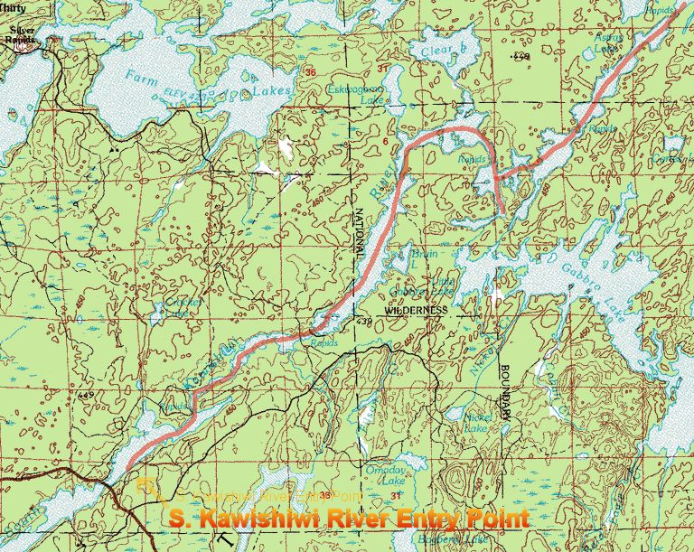
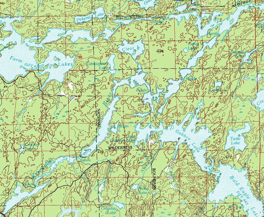
BWCA Solo Kayak Trip - May 2002
![]()
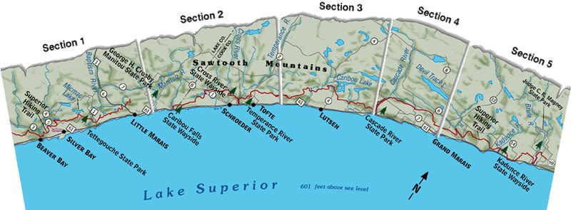
Superior Hiking Trail Trip (Memorial Weekend)
| Length: 7.6 |
This hike leads to some of the more impressive terrain on the SHT, including the high cliffs overlooking the Sawmill Valley, popular with local rock climbers and known to them as section 13. There is an impressive boardwalk that has been constructed over a beaver dam and glacial erratic the is over 20 feet tall. The hike ends with a trek through the valley that includes the east branch of the Baptism river.
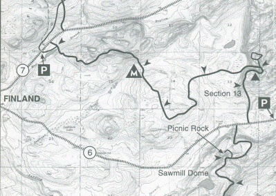
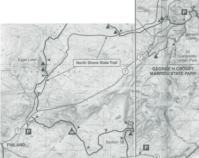
I propose the we plan to continue from where we left off on last year's hike. I think this would be the County Road 6 parking lot (where we left our car) to the Finland Rec Center (that is where we dropped off that first group of hikers). This is a new section (it used to be a major break in the trail) and doesn't show as being continuous on most maps. It doesn't look like there are a lot of good campsites, so I would say we should get an early start and plan on camping in the next section.
![]()
| Length: 11.8 |
This section, while longer is relatively level hiking. It offers a wide variety of terrain and forest types. SHT passes through mixed hardwood forests, groves of large cedars, excellent moose habitat and past two spectacular inland lakes. Unique features of this section are the old trappers cabin and the boardwalk to the island on Sonju Lake.
| Name | Tent Pads |
Setting |
|---|---|---|
| South Egge Lake | 4 | On lakeshore with view of opposite shore |
| North Egge Lake | 4 | On lakeshore |
| South Sonju Lake | 4 | 200 feet from lakeshore |
| North Sonju Lake | 4 | On lake shore |
| East Branch Baptism River | 4 | River bank |
| Blesner Creek | 4 | In cedar grove at intersection of creek and river |
| Aspen Knob | 3 | On knob adajacent to SHT. |
| Disappearing Pond | 3 | 2.0 miles from Crosby-Manitou State Park parking lot. |
There are a lot more campsites in this section and it sounds like easy walking. The next section leads us to George Crosby Manitou SP (where we when on that fall backpacking trip a couple of years ago).
![]()
| Length: 8.1 |
 This
section of the SHT is quite dramatic in terms of topography, offering broad
views of both inland ridges, ponds, and rivers, and of Lake Superior. The SHT
here is more rugged than most sections and visits a variety of forest habitats.
The western half of the section skirts valley of the wild Manitou River, while
the eastern half explores the cedar groves of the dramatic Caribou River Gorge.
This
section of the SHT is quite dramatic in terms of topography, offering broad
views of both inland ridges, ponds, and rivers, and of Lake Superior. The SHT
here is more rugged than most sections and visits a variety of forest habitats.
The western half of the section skirts valley of the wild Manitou River, while
the eastern half explores the cedar groves of the dramatic Caribou River Gorge.
| Name | Tent Pads | Setting |
|---|---|---|
| Crosby Manitou State Park | 28 | Wide variety |
| Horseshoe Ridge | 2 | 4.0 miles east of C-M parking lot. |
| West Caribou River | 4 | 1.0 mile from Caribou Wayside parking |
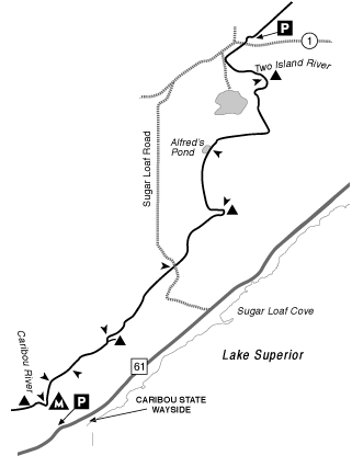
I think our best bet might be to bypass the SP for campsites and maybe try the Horseshow ridge site.
![]()
| Length: 9.0 |
 After
ascending the beautiful and dramatic Caribou River gorge, this section of the
SHT follows a series of ridges and overlooks through mixed deciduous woods. The
bog vegetation of the Alfred's Pond area is a quiet highlight. Lots of evidence
of logging, including roads and clearcuts, helps the hiker understand the role
of logging in forest ecology. Although this section is lengthy, it is one of the
easier sections to hike - perfect for a long nature walk.
After
ascending the beautiful and dramatic Caribou River gorge, this section of the
SHT follows a series of ridges and overlooks through mixed deciduous woods. The
bog vegetation of the Alfred's Pond area is a quiet highlight. Lots of evidence
of logging, including roads and clearcuts, helps the hiker understand the role
of logging in forest ecology. Although this section is lengthy, it is one of the
easier sections to hike - perfect for a long nature walk.
Campsites
| Name | Tent Pads | Setting |
|---|---|---|
| East Caribou River | 8 | 0.7 miles from Caribou ws prking lot. Near the Caribou River crossing. |
| Crystal Creek | 4 | 1.5 miles west of Sugarloaf road. 350' off SHT. |
| Ridge | 3 | 1.2 miles east of Sugarloaf road. |
| Dyer's Creek | 4 | 1.1 miles west of county road 1. |
This looks like an interesting section, I don't know about camping though.
![]()
| Length: 8.0 |
 This
section of the SHT offers a comprehensive look at the steep character of the
region's watershed. The climb to Tower overlook, the descent to Fredenberg
Creek, and the hike along the marsh set the stage for the highlight of the
section, the historic Cross River. Also, there is a ample evidence of both
recent and historic logging.
This
section of the SHT offers a comprehensive look at the steep character of the
region's watershed. The climb to Tower overlook, the descent to Fredenberg
Creek, and the hike along the marsh set the stage for the highlight of the
section, the historic Cross River. Also, there is a ample evidence of both
recent and historic logging.
| Name | Type | Tent Pads |
Water | Setting |
|---|---|---|---|---|
| Fredenberg Creek | Regular | 4 | Creek | 1.8 miles east of county road 1. |
| North Cross River | Regular | 3 | River | 5.3 miles from county road 1, above river. |
| South Cross River | Regular | 4 | River | 1.5 miles up spur trail from Schroeder, above river. |
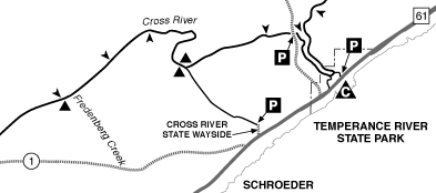
Well, that totals 44.5 mile which would be about 12-14 miles per day for a 3 1/2 day hike. As I get to the end of this I think it might work better to park at the southern end, hike north and ride the shuttle back, or catch the shuttle and ride north, then hike south.
![]()
This page was last updated on April 12, 2002